Member of the following organizations:
Weather Underground
|
Mid-South Weather Network
Mid-South Weather Network
MSWN
|
|
Temperature [ F° ]
Dew Point [ F° ]
Humidity [ % ]
Wind [ mph ]
Rain Today [ in ]
Pressure [ inHg ]
Fire Danger [Chandler Burning Index]
|
|
[ ] Weather, WebCam, Lightning,
[ ] Weather, WebCam, Lightning,
[ ] Weather, Lightning,
[ ] Weather, Lightning,
[ ] Weather, WebCam,
[ ] Weather, WebCam,
[ ] Weather ] Weather
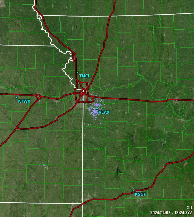
Conditions data shown was collected
from Sun, 05-May-2024 10:07:50 to Sun, 05-May-2024 10:12:08
Regional mesonet-map script by Saratoga-Weather.org
Stations Features
- Louisiana
- New Mexico
- Tatum
[ Weather, Webcam ]
- Oklahoma
- Texas
Regional Mesonets
- Africa
- Canada
- Europe
- Pacific
- USA
- Alaskan Weather Network (AKWN) [Home Site] Stations in AK
- Mid-Atlantic Weather Network (MAWN) [Home Site] Stations in PA, NJ, WV, VA, DE, MD, DC
- Mid-South Weather Network (MSWN) [Home Site] Stations in TX, OK, AR, LA
- Midwestern Weather Network (MWWN) [Home Site] Stations in MN, WI, MI, IA, IL, IN, OH, MO, KY
- Northeastern Weather Network (NEWN) [Home Site] Stations in PA, NJ, NY,CT, RI, MA, VT, NH, ME
- Northwest Weather Network (NWWN) [Home Site] Stations in WA, OR, ID, MT
- Plains Weather Network (PWN) [Home Site] Stations in OK, KS, ND, NE, SD
- Rocky Mountain Weather Network (RMWN) [Home Site] Stations in WY, CO, NM
- Southeastern Weather Network (SEWN) [Home Site] Stations in TN, NC, SC, MS, AL, GA, FL
- Southwestern Weather Network (SWN) [Home Site] Stations in AZ, CA, HI, NV, UT
Regional Networks created by Saratoga-Weather.org along with the Global Afilliated Regional Networks hub site at NorthAmericanWeather.net.
[About]

|