| NWS Weather Forecast -
Outlook Tonight & Wednesday |
Tonight

Mostly Clear
Lo 63°F
|
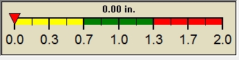
NWS forecast: Mostly clear, with a low around 63. Northwest wind around 5 mph.
WXSIM forecast: Mostly cloudy. Patchy light fog. A slight chance of rain in the morning, then a chance of rain in the afternoon. Scattered thunderstorms likely. High 88°. UV index up to 6. Wind west-northwest around 3 mph. Chance of precipitation 60 percent. Precipitation mostly around a quarter of an inch.
Local station forecast: Mostly clear. Lows in the lower 60s. West winds around 5 mph. |
Wednesday

Sunny
Hi 87°F
|
NWS forecast: Sunny, with a high near 87. West wind 2 to 6 mph.
WXSIM forecast: Moderate fog. A chance of rain in the evening, then a slight chance of rain after midnight. Scattered thundershowers possible. Low 68°. Wind northwest around 3 mph in the evening, becoming north after midnight. Chance of precipitation 50 percent. Precipitation mostly around a quarter of an inch.
|
|
| NWS Short Term Weather Forecast |
|
Wednesday
Night
Mostly Clear
|
Thursday

Sunny
|
Thursday
Night
Mostly Clear
|
Independence
Day
Sunny
|
Friday
Night

Partly Cloudy
|
Saturday

Slight Chance Showers And T-Storms
|
Saturday
Night

Chance Showers And T-Storms
|
|
Lo 66°F |
Hi 89°F |
Lo 68°F |
Hi 90°F |
Lo 71°F |
Hi 90°F |
Lo 71°F |
|
ajax-dashboard6.php - Version 6.95e - 01-Feb-2022 - Script by: Scott of BurnsvilleWeatherLIVE.com
Now supported by Saratoga-weather.org Download
|